
A Global and Coordinated Network
GLAFO establishes a coordinated, international network of observatories designed to advance the understanding of land–atmosphere feedbacks across diverse climate regimes and environmental settings. By linking sites through a common scientific framework, the network enables consistent and comparable observations of coupled processes across the subsurface, vegetation and land surface, surface layer, and atmospheric boundary layer. This distributed structure is intended to support both cross-site comparison and the development of transferable process understanding across regions.
The GLAFO concept builds on the recognition that improved understanding of land–atmosphere feedbacks requires observations across all key compartments of the land system, from groundwater and soil through vegetation and the surface layer to the lower troposphere and the interfacial layer at the top of the planetary boundary layer. The network is therefore conceived as a coordinated framework of observatories operating with a common scientific purpose and a broadly standardised configuration across climate zones.
Relevant existing or potential sites include observatories such as ARM Southern Great Plains in the United States, Cabauw in the Netherlands, Lindenberg in Germany, and other long-term supersites that already contain many of the required observational components. The LAFO observatory at the University of Hohenheim provides an operational prototype demonstrating how this concept can be realised in practice over heterogeneous agricultural terrain.
Hierarchical Observatory Design
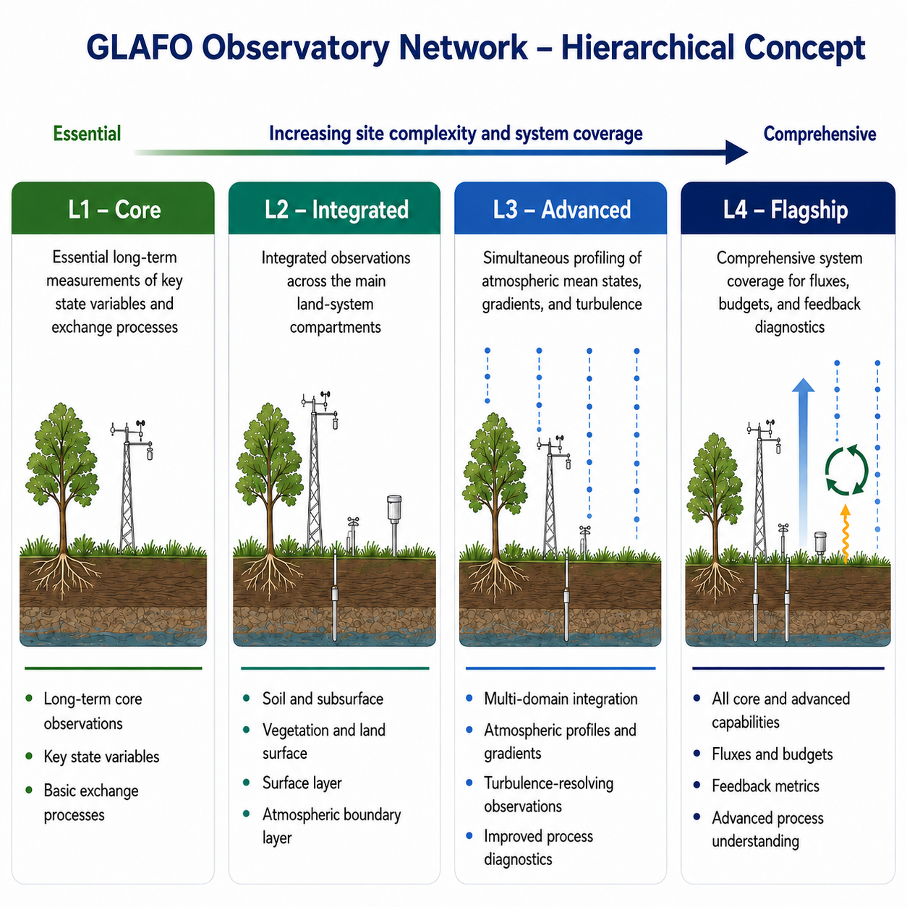
A central feature of the GLAFO network is its hierarchical observatory design. The network is not intended to consist only of identical sites with the same full instrumentation. Instead, it allows observatories with different levels of complexity to contribute within a coherent common framework. Increasing site complexity enables progressively more comprehensive coverage of the coupled land–atmosphere system and supports more advanced process diagnostics and derived data products.
At the core of the concept is a progression from sites that provide essential long-term measurements of key variables and exchange processes to more advanced observatories capable of simultaneous profiling, turbulence-resolving measurements, and full system-oriented analyses of gradients, fluxes, budgets, and feedback metrics. In this way, the hierarchy supports broad participation across the network while also enabling flagship observatories with particularly comprehensive capabilities.
In practical terms, this hierarchy can be understood as a progression from more basic to more comprehensive observatory configurations, for example from L1 to L4. Lower levels would focus on essential long-term measurements of key state variables and exchange processes, while higher levels would include increasingly integrated and advanced capabilities such as simultaneous multi-domain profiling, turbulence-resolving observations, budget closure, and higher-level feedback diagnostics. In this way, the hierarchy reflects both increasing site complexity and increasingly complete observational coverage of the coupled land–atmosphere system.
This logic is consistent with the broader GLAFO concept: dedicated long-term measurements, synergetic observations across the full land system, simultaneous profiling of atmospheric mean states, gradients, and turbulence, and a standard observatory configuration that can be adapted for wider deployment.
The Role of the Hohenheim Prototype
The LAFO observatory at the University of Hohenheim serves as an important prototype within this broader network vision. It was established to provide simultaneous measurements across atmosphere, soil and land surface, and vegetation, with operational measurements complemented by intensive observation periods. This makes it a practical example of how integrated observations can be organised to investigate land–atmosphere feedbacks, heterogeneity of surface and boundary-layer fluxes, and the development of improved parameterisations for models.
Rather than viewing the observatory network simply as a collection of sites, GLAFO conceives it as a coordinated scientific infrastructure. Its purpose is to connect observations, process understanding, and model development across scales and regions, thereby supporting improved representation of land–atmosphere interactions in weather and climate prediction systems.