
GLAFO–Hohenheim: A Prototype in Operation
A concrete example of how the GLAFO concept can be realised in practice is provided by the ongoing work at the University of Hohenheim. Here, the Land–Atmosphere Feedback Observatory (LAFO) serves as a prototype site within the wider Land–Atmosphere Feedback Initiative (LAFI), an interdisciplinary research programme designed around the core principles of the GLAFO framework. In this setting, the observatory is not treated simply as a measurement site, but as the foundation for an integrated scientific programme linking long-term observations, targeted process studies, model evaluation, and the development of improved diagnostics of land–atmosphere feedbacks.
The Hohenheim prototype illustrates the observation-led philosophy of GLAFO particularly clearly. Its measurement strategy is built around simultaneous observations across atmosphere, soil and land surface, and vegetation over heterogeneous agricultural terrain. This enables the scientific investigation of key land–atmosphere processes including the evolution of water and energy balances, the heterogeneity of surface and boundary-layer exchange, and the development of improved parameterisations for weather and climate models. In this sense, the site directly addresses the broader GLAFO goal of linking observations to process understanding and, ultimately, to improved prediction capability.
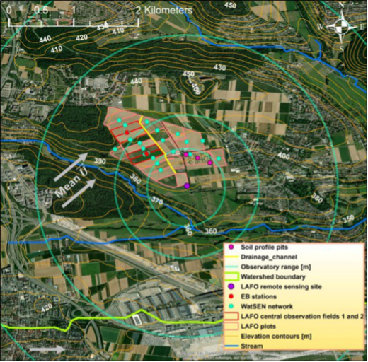
The first figure shows the location of the GLAFO–Hohenheim site south of Stuttgart and situates the prototype observatory within its regional context.
The next two figures demonstrate the kind of advanced atmospheric profiling that can be expected from a higher-level GLAFO site. The ARTHUS water-vapour time–height section, together with the overlaid convective boundary-layer evolution, illustrates how continuous lidar profiling can be used to track the structure and daytime development of the boundary layer. This type of measurement is central to the GLAFO concept because it links near-surface exchange directly to atmospheric response. It shows that the prototype site is able not only to observe conditions at the surface, but also to resolve how humidity structures evolve through the atmospheric boundary layer and how this evolution relates to boundary-layer growth and coupling processes.
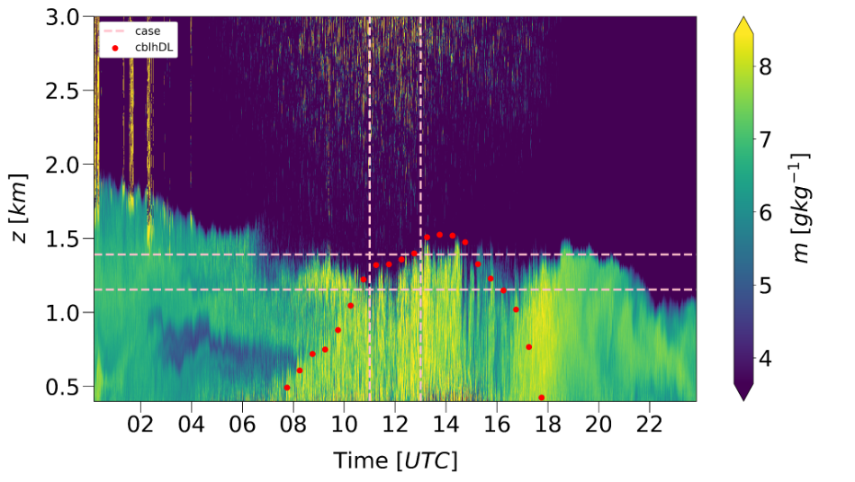
The WVDIAL cross section complements this by showing the fine-scale vertical and temporal structure of absolute humidity in the lower troposphere. Whereas the ARTHUS figure highlights continuous boundary-layer development, the WVDIAL example makes visible the detailed moisture structure that can be resolved within and above the boundary layer. Together, these two figures communicate an important part of the scientific value of the Hohenheim prototype: a GLAFO-type site can provide not only conventional surface observations, but also detailed process-oriented measurements of the atmospheric leg of land–atmosphere feedback.

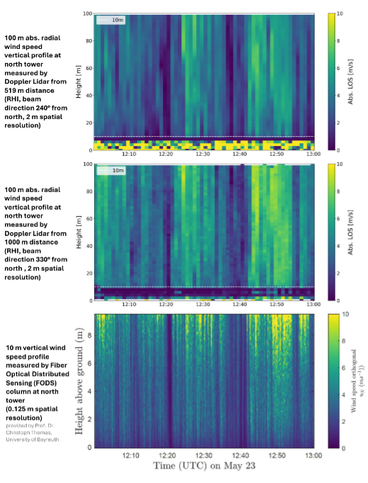
The comparison between Doppler lidar and fiber-optic distributed sensing (FODS) wind measurements further illustrates the role of sensor synergy within the GLAFO framework. The Doppler lidar profiles provide spatially extended wind information through the lower atmosphere, while the FODS observations resolve wind structure within the lowest 10 m at much finer spatial resolution. Their combined use shows how different instruments can be brought together to form a more complete description of near-surface and boundary-layer processes than either could provide alone. This kind of cross-instrument comparison is a strong example of the GLAFO idea that scientific value increases not simply through the number of instruments deployed, but through their coordinated use to resolve linked processes across scales and domains.
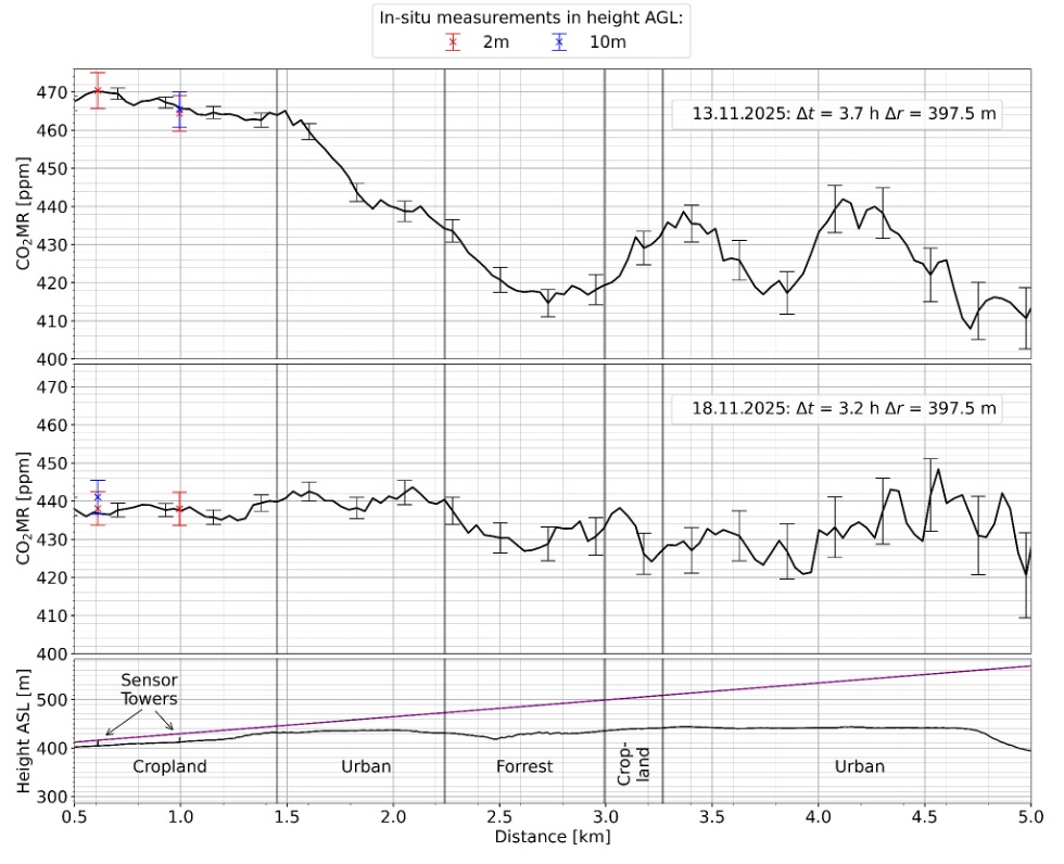
A further example is provided by the comparison between near-ground CO₂ mixing ratio measurements from ARTHUS low-level scans and in-situ observations from sensor towers. Here, the tower measurements provide the conventional near-surface reference, while the lidar extends these observations along the laser path and adds a new spatial dimension to the analysis. The close agreement between lidar and tower data, including several days after calibration, demonstrates that advanced remote sensing at a GLAFO-type site can both support and extend established measurement approaches. In this case, the prototype site does not simply add more instrumentation; it creates the conditions for cross-validation, consistency checks, and spatially distributed observations of variables such as CO₂ that would be difficult to obtain from tower measurements alone.
Taken together, these examples show how the Hohenheim prototype extends beyond a single observatory into a broader scientific framework. Within LAFI, the observational platform supports not only direct measurement and analysis, but also isotope studies, remote sensing applications, turbulence-resolving simulations, Earth system modelling, and machine learning. In this way, the Hohenheim example demonstrates how a project can be built within the GLAFO framework: integrated observations provide the empirical backbone, targeted scientific studies build process understanding, and coordinated analysis across methods and scales turns measurements into transferable insight for future GLAFO-type observatories and programmes.
Research Data Management
The GLAFO–Hohenheim prototype demonstrates that an advanced observatory is defined not only by its measurement capability, but also by the way its data are managed, standardised, and prepared for scientific reuse. Within the wider LAFI framework, research data management is being developed as an integral part of the observatory concept so that complex multi-domain observations can support effective scientific collaboration within and beyond the project, and can be used more directly for model evaluation and future synthesis activities.
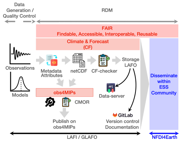
The first figure illustrates the research data management process developed around the Hohenheim prototype. Observational and modelling datasets are brought into a common workflow in which variable names are harmonised across domains, metadata are standardised, and the resulting datasets are stored in netCDF files following the Climate and Forecast (CF) metadata conventions. These harmonised datasets are then checked for compliance and prepared for dissemination through wider Earth system science infrastructures. The workflow also highlights the role of obs4MIPs as a target framework for enabling climate model evaluation, and the role of GitLab and the NFDI4Earth service portfolio for version control, documentation, scripts, and the capture of best-practice workflows. In this way, the observatory is linked not only to measurement and process understanding, but also to the creation of reusable scientific data products that can be discovered, shared, and applied more broadly.
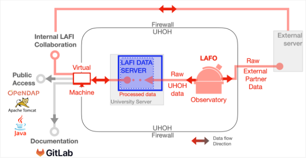
The second figure shows the infrastructure that underpins this workflow. Data generated at the observatory are stored on a secure University of Hohenheim server behind the institutional firewall. A virtual machine provides controlled access for LAFI project partners and forms the basis for internal collaboration, while also creating a pathway toward future public data services. In the longer term, this infrastructure is intended to support openly accessible data provision together with related services such as data-server access, documentation, and web-based dissemination. This highlights an important aspect of the GLAFO concept: an observatory must not only observe the coupled land–atmosphere system, but also provide the data infrastructure required to translate those observations into FAIR, interoperable, and scientifically useful resources.
In this sense, the Hohenheim prototype provides an operational example of how coordinated research data management can be embedded within a GLAFO-type programme. The observatory supports not only integrated measurement and process studies, but also the harmonisation, storage, documentation, and future publication of the resulting datasets. This is essential if GLAFO observatories are to function as part of a broader scientific network in which observations can be compared, reused, and linked systematically to model development and evaluation.