GLASS projects are listed below, along with contact information for reaching the project coordinators.
An overview of GEWEX’s Cross-Panel activities can be found at https://www.gewex.org/cross-panel-activities/.
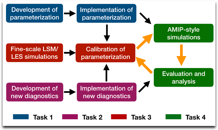
Coupling of Land and Atmospheric Subgrid Parameterizations (CLASP)
Contact: Nathaniel Chaney
The role of sub-grid surface heterogeneity on atmospheric response remains mostly ignored in practically all Earth system models.
The objective of CLASP is to parametrize the heterogeneous sub-grid exchange between the land and atmosphere and characterize its implications for surface climate, variability, and extremes.
GEWEX Atmospheric Boundary Layer Study, Phase 5 (GABLS–5)
Contact: John Edwards,
Within GEWEX Atmospheric Boundary Layer Study (GABLS), intercomparisons are carried out to improve the boundary layer parameterizations schemes used in numerical weather prediction and climate models. The stable boundary layer and deficiencies in its parameterization (Holtslag et al. 2013) have been a central theme in GABLS.
- GABLS–1 intercomparison (Cuxart et al. 2006; Beare et al. 2006) was concerned with the moderately stable boundary layer.
- GABLS-2 (Svensson et al. 2011) and GABLS-3 (Bosveld et al. 2014) intercomparisons explored the diurnal cycle.
- GABLS-4 intercomparisons (Couvreux et al. 2020; Le Moigne et al. 2022) was focused in the antarctic with a very stable boundary layer.
Through the GABLS project, the representation of interactions with the underlying surface has become increasingly important.
The aim of the next phase of the project is to exploit the detailed synergistic observations being made within the GEWEX Land/Atmosphere Feedback Observatory (GLAFO) project to formulate intercomparisons that focus on key processes in the atmospheric boundary layer and its interactions with the land surface. The intercomparisons will involve simulations at a range of resolutions. Whilst we shall initially focus on one site, the aim is to establish a methodology that can be extended to other sites and cases in the future.
The GEWEX Land/Atmosphere Feedback Observatory (GLAFO) project proposes a new sensor synergy and/or enhancements of current observatories and networks to observe the terrestrial and atmospheric legs of land-atmosphere feedbacks, simultaneously. Especially the atmospheric leg and the required observations must be considered as Terra Incognita in the Earth system.
GLAFOs will observe the relevant processes and variables with respect to mass, energy, water, and momentum transport with unprecedented spatial and temporal resolutions, from bedrock to the lower troposphere. The measurements will be realized through the synergistic combination of in-situ instruments as well as and active and passive remote sensing systems, partly with 3D scanning capability. Detailed information is available in the GLAFO Project White Paper.
Irrigation Crosscutting Project
Contact: Tricia Lawston Parker
The Irrigation project is an initiative of the GHP and GLASS Panels to advance our understanding of the impacts of irrigation on the water and energy cycles and to better represent these effects in models. Volunteer efforts and recently funded projects (e.g., LIAISE, GRAINEX, Irrigation+) have demonstrated the importance of understanding the role of irrigation in the earth system and the challenges of identifying and modeling irrigation water usage and impacts. The Irrigation project seeks to improve the representation of irrigation in models by working together to identify pressing issues, enhancing collaboration among groups working on related problems, and leveraging products and methods yielded by existing projects.
Irrigation accounts for about 70% of global freshwater withdrawals and about 90% of consumptive use, significantly altering the natural water cycle. Although an increasing number of weather and climate models include some representation of irrigation, these parameterizations are often crude and difficult to evaluate with limited observations.
The irrigation project seeks to better understand:
- Global and regional irrigation water use
- The impacts of irrigation on the water and energy cycles
- The downstream effects of irrigation on weather and climate
These goals are achieved in part by enhancing communication among existing groups working independently on irrigation topics, facilitating the formation of subgroups and collaborations for proposal and paper writing, etc.
Local Land-Atmosphere Coupling (LoCo) Working Group
Contact: Joe Santanello
Land-Atmosphere (L-A) interactions and feedbacks are complex, and require a quantitative, integrative, and process-level understanding that begins at the local level. The local L-A coupling (LoCo) perspective is one that enables such understanding via the connections of land surface and atmospheric (namely planetary boundary layer (PBL)) variables using a process-chain paradigm that outlines the connections from soil moisture to precipitation. To address this, the LoCo effort in GLASS is currently organized around a working group comprised of both panel and non-panel members.
Over the last 10-15 years, LoCo has led the development of a suite of L-A coupling diagnostics and applications to models across a range of scales. In addition, the working group is actively involved in developing and augmenting field campaigns to support L-A research and identify future observational needs.
The LoCo group has galvanized the young scientist community, and in turn has led to a productive scientific publication record and community leadership in L-A research. LoCo resources include metric summaries, a software toolkit, and a BAMS overview article to enable broader exposure/use of these techniques within the community, and to expand the application of LoCo metrics to the various modeling communities (research and operational).
Machine Learning for Land Modeling (ML4LM)
Contact: Souhail Boussetta
The continuous improvement in computer sciences and HPC systems on one hand, and on the other hand, more accurate and frequent observations, especially satellites-based ones, are now easily available the science community. These developments allow for a paradigm shift between considering physical-based models and data driven models or both combined together.
With the increasing use of machine learning for Earth system studies, this project aims at exploring the extent of the role that machine learning could play for better land surface studies, especially identifying the main areas where it could be applied and pointing to/providing tools and data to the land surface modeling community.
Machine Learning for Land Modeling Presentation
Protocol for the Analysis of Land Surface models (PALS) Land Surface Model Benchmarking Evaluation Project, Phase 2 (PLUMBER2)
Contact: Gab Abramowitz
PLUMBER2 is a model comparison experiment that is aiming to try to better understand land surface predictability. It involves analysis of model simulations at 170 flux tower sites by land surface, hydrology and ecosystem models, as well a range of different out-of-sample empirical models used as benchmarks. PLUMBER2 follows on from PLUMBER (Best et al, 2015, Journal of Hydrometeorology) using many more sites, a wider range of land models and empirical model approaches, as well as expanding analyses to include phase lags, variable ratios, information theoretic approaches and error correlation amongst contributing models. All model outputs, observational data and analyses are within the modelevaluation.org platform, with more detail about the experiment itself in the PLUMBER2 protocol document.
Land Surface Model for Solar Induced Fluorescence (SIF-MIP)
Contacts: Nicholas Parazoo, Jen Johnson, Troy Magney and Alexander Norton
Recent successes in passive remote sensing of far-red solar-induced chlorophyll fluorescence (SIF) have spurred the development and integration of canopy-level fluorescence models in global terrestrial biosphere models (TBMs) for climate and carbon cycle research. The interaction of fluorescence with photochemistry at the leaf and canopy scales provides opportunities to diagnose and constrain model simulations of photosynthesis and related processes, through direct comparison to and assimilation of tower, airborne, and satellite data. TBMs describe key processes related to the absorption of sunlight, leaf-level fluorescence emission, scattering, and reabsorption throughout the canopy.
The SIF model intercomparison project (SIF-MIP) focuses on targeted assessments of simulations from an ensemble of process-based TBM-SIF models, forced with local meteorology and analyzed against tower based continuous far-red SIF, and net and gross carbon (Net Ecosystem Production, Gross Primary productivity) and energy exchanges (evapotranspiration, sensible heat flux). Our basic protocol follows the Phase 1 SIF-MIP study, which focused on single point simulations of diurnal variability at Niwot Ridge, Colorado (Parazoo et al., 2020) using prescribed model inputs, designated model outputs, within model experiments (e.g., with/without data assimilation, different process representation), and spin-up and data constraints (e.g., prescribed vegetation) at PI discretion. Phase 2 of SIF-MIP will expand the time and spatial scale of analysis, focusing on diurnal, synoptic, and seasonal variability at evergreen needleleaf (Old Black Spruce, Niwot Ridge, Delta Junction) and crop (Iowa corn and soybean) sites in North America.
GEWEX Soil and Water (SoilWat) Initiative
Contacts: Yijian Zeng (GLASS panel representative), Anne Verhoef (thermal properties), Dani Or (soil evaporation/hydraulic properties), Matthias Cuntz, Lukas Gudmundsson, Stephan Thober (SPMIP), Lutz Weihermueller, Tobias Weber (PTFs/hydraulic properties), Stefan Kollet, Laura Condon (groundwater), Harry Vereecken (PTFs/hydraulic properties, infiltration), Jan Vanderborght (soil-root interactions), and Kathe Todd-Brown (soil carbon)
The GEWEX-ISMC* SoilWat Initiative brings together two research communities to improve the representation of soil and subsurface processes in climate models. The soil and groundwater community and the climate modeling community (the latter represented by GEWEX) are working together to identify the most pressing challenges and topics related to this effort.
*International Soil Modelling Consortium
Finished Projects
Contacts: Aaron Boone and Christophe Peugeot
In ALMIP2, land surface, vegetation, and hydrological models have been evaluated and inter-compared in order to identify key processes that were not well-modeled over West Africa, and to offer guidelines for future model development for all three classes of models. Phase two has dealt with local to meso scales.
DIurnal land/atmosphere Coupling Experiment and GEWEX Atmospheric Boundary Layer Study 4 (DICE/GABLS4) (2015 – 2018)
Contact: Adrian Lock and Martin Best
The Diurnal land-atmosphere Coupling Experiment (DICE) proposed a simple methodology for assessing the impact of atmosphere feedbacks by first assessing the individual components constrained by observational data and then identifying changes due to coupling. This is based on data collected during CASES-99 field campaign.
Within GABLS (GEWEX Atmospheric Boundary Layer Study), inter-comparison studies are carried on for boundary layer parameterizations schemes in use by numerical weather prediction and climate models. Under stable stratifications, models still have large biases, which depend on the parameterizations used for boundary layer and for surface (Holtslag et al, 2013, BAMS). The first three GABLS inter-comparison studies (Cuxart et al. 2006, Svensson et al 2011, Bosveld et al 2014) dealt only with moderate stable conditions.
The GABLS4 (DICE-over-ice) project, a joint activity between GLASS and GASS, studied the interactions between the ice/snow- surface & atmospheric boundary layer under conditions of strong stability. It followed on to earlier GABLS studies with focus on very stable conditions, and a surface with low conductivity and high cooling potential over snow/glacier.
The GABLS4 project finished with the GABLS4 Workshop hosted by Météo France in Toulouse, France in September 2018.
Global Soil Wetness Project, Phase 3 (GSWP-3) (2014-2024)
Contact: Hyungjun Kim
GSWP3 is an ongoing terrestrial modeling activity that produces a long-term land reanalysis and investigates the changes of the energy-water-carbon cycles through the 20th and 21st century. A wide range of state-of-the-art land surface, hydrologic, and ecological models make up super-ensemble land simulations combining big data, and are evaluated by process-wise model verifications and uncertainty estimations. GSWP3 also plays a role as a liaison, sharing experiment designs and input datasets as a standard for the broader modeling community.
Contact: Dave Lawrence, NCAR
The International Land Model Benchmarking (ILAMB) project is a model-data intercomparison and integration project designed to improve the performance of land models and, in parallel, improve the design of new measurement campaigns to reduce uncertainties associated with key land surface processes. Building upon past model evaluation studies, described below, the goals of ILAMB are to:
- Develop internationally accepted benchmarks for land model performance.
- Promote the use of these benchmarks by the international community for model intercomparison, including coupled and land-only simulations in CMIP6 and other MIPs.
- Strengthen linkages between experimental, remote sensing, and climate modeling communities in the design of new model tests and new measurement programs.
- Support the design and development of an open source benchmarking software system for use by the international community.
Land Surface, Snow and Soil Moisture Model Intercomparison Project (LS3MIP)
Contacts: Bart van den Hurk, Gerhard Krinner, Sonia Seneviratne, Chris Derksen, Hyungjun Kim and Taikan Oki
The LS3MIP experiment intends to assess the performance of current land surface modules of Earth System Models and quantify land surface feedbacks in a changing climate. Its goal is to provide a comprehensive assessment of land surface-, snow-, and soil moisture-climate feedbacks, and to diagnose systematic biases in the land modules of current ESMs using constrained land-module only experiments.
Land Use Model Intercomparison Project (LUMIP) (2016 – 2021)
Contact: Dave Lawrence, NCAR
Human land-use activities have resulted in large changes to the Earth surface, with resulting implications for climate. In the future, land-use activities are likely to expand and intensify further to meet growing demands for food, fibre, and energy.
The Land Use Model Intercomparison Project (LUMIP) further advances understanding of the impacts of land-use and land-cover change (LULCC) on climate, specifically addressing the questions: (i) What are the effects of LULCC on climate and biogeochemical cycling (past-future)? (ii) What are the impacts of land management on surface fluxes of carbon, water, and energy and are there regional land-management strategies with promise to help mitigate against climate change? LUMIP also addresses a range of more detailed science questions to get at process-level attribution, uncertainty, data requirements, and other related issues in more depth and sophistication than previously.
LUMIP involved three major sets of science activities:
- development of an updated and expanded historical and future land-use dataset,
- an experimental protocol for specific LUMIP experiments for CMIP6, and
- definition of metrics and diagnostic protocols that quantify model performance with respect to LULCC.