Humans and Hydroclimate in the United States (H2US; formerly the “US-RHP”) a cohesive multi-institutional effort to understand and address a changing hydroclimate in the United States.
Since the Global Energy and Water Exchanges (GEWEX) Continental-Scale International Project (GCIP) in the 1990s and the GEWEX Americas Prediction Project (GAPP) in the 2000s, the GEWEX community has sought to organize a new RHP in the United States that evolves and builds from these earlier experiments, and speaks directly to the dynamically evolving Earth systems challenges we face.
Mission
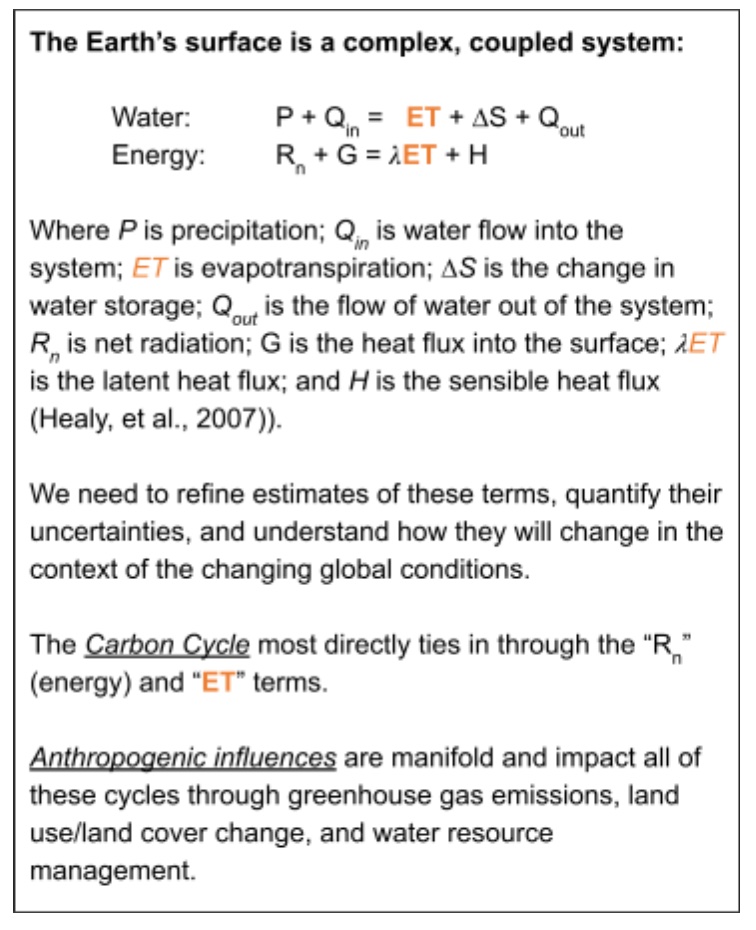
The Humans and Hydroclimate in the United States (H2US) Project is envisioned as a ten-year effort to understand and characterize the physical processes of the water, energy, and carbon cycles in the Anthropocene. This is driven by a need for actionable science solutions to achieve water, food, and energy security in the U.S.
Goals and Working Groups
Goals associated with this mission include:
- Improve understanding of factors that enhance the production of actionable hydroclimate modeling tools and products
- Improve understanding of how the development and application of hydroclimate modeling tools can advance food, water, and energy security, in awareness and support of ecosystem health and sustainability for all
- Understand hydroclimate predictability at subseasonal to seasonal (S2S) to decadal scales, how predictability may be changing and what risks this poses for society, and how best to harness and improve our predictive skill with observations, methods, and models
- Improve understanding of physical and dynamic mechanisms and human interventions that underlie the water-energy-food nexus and interaction and associated impacts on socio-economic factors, particularly under extreme weather in a changing climate
- Identify impacts of anthropogenic changes in climate, land use, water use, and water management on water and energy across scales
- Quantify critical and unknown hydrologic stores (groundwater, rock/soil water, snowpack) and fluxes (evapotranspiration)
- Improve understanding of hydrologic variability at multiple, coupled scales
- Understand the critical linkages associated with compound and cascading extreme events
- Understand how changes in climate and catchment physical condition co-evolve and cascade from the atmosphere to the land surface, shaping catchment susceptibility to extremes
- Broaden participation in multidisciplinary hydroclimate science, observation, modeling, and applications research
- Co-create usable data, tools, and case studies with and for educational and community users.
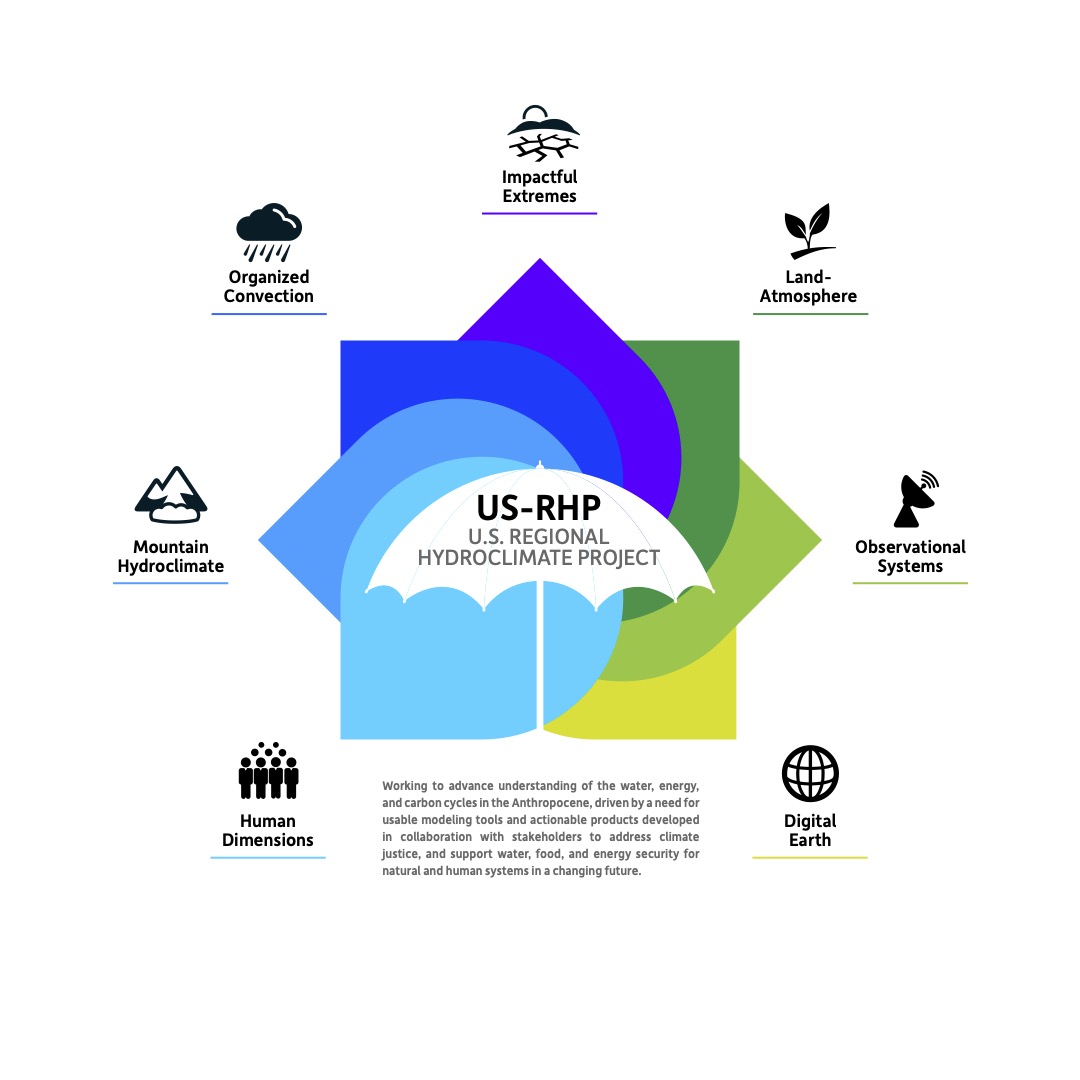
Our technical efforts are currently organized around seven working groups as illustrated fig. 1.
Geographic Scope and Activities
The rather expansive focus of the US-RHP is the CONUS, plus Alaska and Hawaii. This “regional” domain encompasses a wide range of geomorphologies, land uses and land cover, weather phenomena, and localized climates. The region also interacts with, and is influenced by global phenomena such as dynamical processes (e.g. El Nino/La Nina, teleconnections), climate change, and large scale events (dust storms, volcanic eruptions, etc.).
There will be a range of modeling activities that span spatial and temporal scales: from the global to the regional to the local (e.g. a watershed). These modeling efforts will be supported by sub-regional focal studies driven by observational campaigns, which are optimally coordinated into transects that leverage existing as well as new assets (fig. 2).
The map in the center of fig. 2 prescribes our definition of CONUS for the purposes of the US-RHP, and notionally illustrates the idea of observational “transects” (the gray ellipses are not actual or even proposed transects, they are simply possible ones for illustrative purposes). It should be noted that the initial bounding box for the US-RHP represented by this map is partly informed by geographic scope of what can be practically modeled today at finely-resolved scales (~4 km resolution) over decadal time scales.
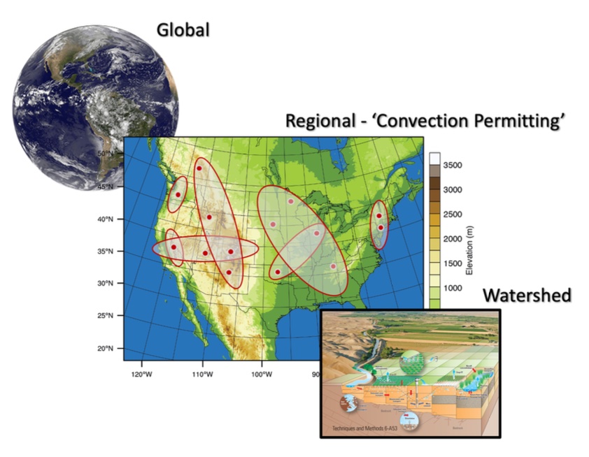
The map in the center of fig. 2 prescribes our definition of CONUS for the purposes of the US-RHP, and notionally illustrates the idea of observational “transects” (the gray ellipses are not actual or even proposed transects, they are simply possible ones for illustrative purposes). It should be noted that the initial bounding box for the US-RHP represented by this map is partly informed by geographic scope of what can be modeled today at finely-resolved scales (~4 km resolution) over climate time.
Motivation
The last time that there were any comprehensive land-atmosphere studies in the U.S., were GCIP running from 1993 to 2000 and GAPP running from 2001 to 2007.
Since these first RHPs, the rest of the world has conducted numerous RHPs and the U.S. is lagging behind. Now is the time for a new large, coordinated effort focused on land-atmosphere processes. This calls for an RHP that reflects the physical realities presented by the Anthropocene that are unique to our geography, and that integrates and represents the human dimensions that exert a strong influence on the natural systems.
For the GEWEX US-RHP Summary Science plan click here.